I am an Urban Science Faculty Fellow at the Center for Urban Science and Progress at New York University. I recently completed a PostDoc and PhD in Geographic Information Science at the Spatial Analysis Research Center (ASU) with a focus on computational methods and local regression models to analyze urban processes with applications in crime, housing markets and urban health outcomes amongst others. I have prior experience as a geospatial data scientist at Carto (a SaaS web-mapping platform) and have a graduate degree in urban planning and analytics from Columbia University and an undergraduate degree and professional background in architecture. As a passionate researcher and an urban enthusiast, everything I have engaged in so far has been driven by a keen interest in the coexistence of urbanity and ecology and the impact of human footprint on the environment. In my spare time I run, hike, paint and read.

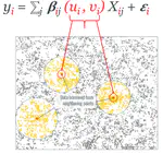
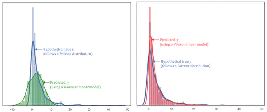
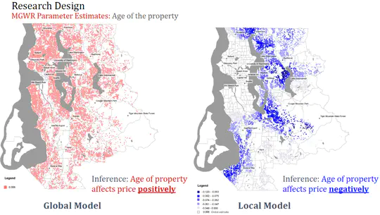
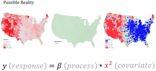
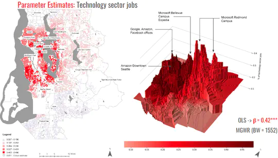
Representative research on a geographical perspective on Simpson’s Paradox and the scale of processes between local and global models:

demo demo
Education
  • PhD in Geographic Information Science, 2022

    Arizona State University

  • Master of Science in Urban Planning, 2016

    Columbia University

  • Bachelor of Architecture, 2013

    The Maharaja Sayajirao University of Baroda, India

Publications

Quickly discover relevant content by filtering publications.
(2022). Local Modeling in a Regression Framework. Spatial Analysis in the Social Sciences Handbook, eds. S. Rey and R. Franklin..

(2022). A Geographical Perspective on Simpson’s Paradox.

(2022). Are We Measuring Spatial Nonstationarity or Nonlinearity. Geographical Analysis..

DOI

(2022). The Geographically Weighted Regression Framework.. The Geographic Information Science & Technology Body of Knowledge (4th Quarter 2020 Edition).

DOI

(2022). Using the specification curve to teach spatial data analysis and explore geographic uncertainties. Journal of Geography in Higher Education.

DOI

(2022). A Replication of DiMaggio et al. (2020) in Phoenix, AZ. Annals of Epidemiology.

DOI

(2022). A scoping review on the multiplicity of scale in spatial analysis. Journal of Geographical Systems.

DOI

(2022). On the importance of thinking locally for statistics and society.. Spatial Statistics.

DOI

(2022). Do places have value? Quantifying the intrinsic value of housing neighborhoods using MGWR. Journal of Housing Research 0(0):1–29.

DOI

Projects

*
Multiscale Spatially Varying Poisson Model
A recent addition to the local statistical modeling framework is the implementation of the Multiscale Geographically Weighted Regression (MGWR) model, a multiscale extension to the widely used approach for modeling process spatial heterogeneity, Geographically Weighted Regression (GWR).
Multiscale Spatially Varying Poisson Model
Local Modeling Perspectives on Scale Issues
The concept of ‘spatial scale’, or simply ‘scale’ is implicit in any discussion of global versus local models. The raison d’etre of local models is that a global scale (where here ‘global’ simply refers to all locations within a predefined area of interest) might be the incorrect scale at which to undertake any analysis of spatial processes; the alternative being a local scale (where here ‘local’ refers to individual locations).
Local Modeling Perspectives on Scale Issues
Diagnostics for appropriate model form
Studies of spatially varying parameter estimates obtained in the calibration of various types of local statistical models are commonplace. The variation in such estimates is typically explained in terms of spatially varying processes.
Diagnostics for appropriate model form
Local House Price Modeling
Real estate market analysis has long been an active area of inquiry and one that reveals much about people’s preferences regarding housing attributes. It is well-known that house prices tend to exhibit strong spatial dependency and that they vary across space due to differences in structural and neighborhood characteristics.
Local House Price Modeling
City Studio - Advances toward the “20-Minute City” vision for Tempe
City Studio is an Arizona State University (ASU) course developed to allow ASU and the City of Tempe to collaborate on Tempe’s 20-Minute City project. ASU worked with Tempe staff to develop the City Studio class.
City Studio - Advances toward the “20-Minute City” vision for Tempe
CARTO - Research and Development
Space-time Autocorrelation using NYC taxi data (2015) This project explores spatial and temporal autocorrelation. Open-source yellow taxi trip data for the year 2015 was aggregated to a 50m * 50m grid across NYC.
CARTO - Research and Development
CARTO - Workshops and Contributions
My first contribution to the CARTO environment was to develop materials for the Carto Academy depicting how to implement and interpret spatial tools on the web GIS platform. This has since been deprecated to accommodate for changes in the version of the current software.
CARTO - Workshops and Contributions
Resilient Island Culture Studio, Staten Island
The Resilient Island Culture Studio was tasked to address housing and resiliency issues on Staten Island in the aftermath of Hurricane Sandy. With Make the Road New York as the studio client, emphasis was placed on serving lower-income communities that have not fully recovered from the storm.
Resilient Island Culture Studio, Staten Island
Efficiency and Accessibility of NYC and Chicago Subway networks
As wealth gaps increase in American Cities certain lower income populations in cities will grow more vulnerable if their transportation needs are not met. We can use GIS to spatially research where the highly dense areas are that may be currently underserved by existing Subway infrastructure in cities.
Efficiency and Accessibility of NYC and Chicago Subway networks
Environmental justice study - New York City and Chicago
Concerned with environmental injustice and the many ill-impacts it has on the residents of affected neighborhoods, I realized through existing literature that there were sources of toxic air pollutants existing within close proximity to our daily land-uses.
Environmental justice study - New York City and Chicago
Reclamation Institute for Social Ecology
In 2013, deeply concerned about rampant mining in some parts of India and their subsequent abandoning I came across some abandoned asbestos mines, south of the city of Udaipur that had left a toxic trail for the community dwellers to deal with.
Reclamation Institute for Social Ecology
Resurgence of the City Center
In this urban theory studio during my undergraduate studies in architecture, the aim was to study and implement a plan for the resurgence of the center of the city of Vadodara, India, long known for its Colonial architectural style.
Resurgence of the City Center

Teaching Experience


Co-Instructor
GIS-563 - Local Statistical Modeling
Oct 2022 – Dec 2022 ASU, Tempe

Description:

  • Concepts on local statistical modeling
  • Teaching how to implementing related software and understand inference


Instructor
GIS-322 - Programming Principles in GIS II
Jul 2022 – Aug 2022 ASU, Online


Instructor
GIS-211 - Geographic Information Science II
Aug 2021 – Dec 2021 ASU, Tempe


Co-Instructor
GIS-322 - Programming Principles in GIS II
Jul 2021 – Aug 2021 ASU, Online


Graduate Course - Assistant Developer
GIS-471 - Spatial Statistics
Aug 2019 – Dec 2019 ASU, Online

Responsibilities include:

  • Contributing to construction of course material


Graduate Teaching Assistant
Advanced GIS
Sep 2015 – May 2016 Columbia University, NYC

Description:

  • Advanced concepts in GIS (Medium - ESRI software and Python)
  • Syllabus


Graduate Teaching Assistant
Sustainable Urban Development - International Perspectives
Feb 2015 – May 2015 Columbia University, NYC

Responsibilities include:

  • Assisting with course development
  • Updating outdated lectures and circulating relevant course content

Professional Experience


Geospatial Data Scientist
Jun 2016 – Aug 2017 Brooklyn, NYC

Responsibilities include:

  • Analysing
  • Modeling
  • Deploying new tools within the Carto environment
  • Contributing to Carto Academy


Education and Data Intern
May 2016 – Jun 2016 Brooklyn, NYC

Responsibilities include:

  • Contributing to Carto Academy
  • Held workshops to promote use of geospatial technologies


Urban Planner
GWW Planning and Consultancy
May 2016 – Aug 2016 Manhattan, NYC

Responsibilities include:

  • Drafting planning ideas for neighborhood projects


Development Intern
Jan 2016 – May 2016 Manhattan, NYC

Responsibilities include:

  • Analysis for neighborhood planning projects
  • Community engagement and meetings


Data Analyst and Developer
SHoP Architects and Center for Spatial Design
Jan 2015 – Jan 2016 Manhattan, NYC

Responsibilities include:

  • Creating clean network data for node analysis


Resiliency Planning Intern
New York City Department of City Planning
May 2015 – Aug 2015 Staten Island, NYC

Responsibilities include:


Architect
May 2013 – Jul 2014 Ahmedabad, India

Responsibilities include:

  • Designing for institutional projects
  • Drafting ideas for design competitions
  • Working drawings for on-site construction